
The second phase of the Web Mapping project includes an interactive Census-GIS solution for the user requiring more than just a pre-prepared image map. Researchers can make use of this section to generate their own maps and use them in other documents and reports.
An example of a Geographical Information System in action is given in this section. In effect this section provides a complete Census GIS which can be accessed over the internet as well as at the user's end. Due to the large volume of data available, both an on-line and a CD version have been produced.
The on-line version comprises 2047 ArcExplorer files. Each file can be queried and analysed by the user. Thematic maps and query results can be saved as per user's needs. These files are zipped for faster download times and easier access.
The CD version is not zipped since it allows better access to data than the on-line version since the user can make use of ArcExplorer projects format through which various data sets can be accessed simultaneously, making overlaying possible. This version is comprised of 2047 maps set out in 184 projects. Files are left in the native ArcExplorer format (*.shp). The CD version is available in 4 CDs.
This page gives an overview of the following:
ArcExplorer: Downloading
This phase requires downloading ArcExplorer. This GIS software, created by the Environmental Systems Research Institute (ESRI), is a user-friendly, light and easy to familiarise oneself with. The software is distributed as freeware. ArcExplorer is currently in Version 1.1 can be downloaded from the ESRI site by following the link below.
ArcExplorer 1.1 (aeclient.exe) has a file size of 7.2 MB and includes an ArcExplorer User Guide (arcexplorer.pdf).
The Works
Once the software has been installed in order to access data relevant to each of the Census categories click on the relevant section in the titlebar above. Each section will activate the relevant lists of files which can be downloaded. The titlebar pointers are coded and the full names are described in the Categories Table below:
Categories
Category Code
Category Name
Each file is zipped and can be dragged into the ArcExplorer active theme area. The file opens in a designated area on the user's harddisk and thematic mapping as well as querying can then take place at the user's end. This option allows the user to fully interact with the Census data and to produce maps as requested. Outputs can then be ported to other software and exported as image files. Data can also be queried as per user's needs and outputs saved in ascii format.
However, for this study, it was deemed appropriate to develop the Malta Census datasets into a series of maps that can be easily downloaded for use at the user's end. In effect, this amounts to the development of a Census GIS that can work both over the Internet or an intranet and as a stand alone at the user's end. Due to some restrictions put upon the users both as to dataset size and lack of project formats over the web, the best option at this stage is to download a zip file over the Internet and work at the user's end.
Note that the large number of files produced for each dataset is the direct result of the map conversion and integration stages of the CensArc project. The process is complicated due to the fact that converting MapInfo *.tab format (original source data format) to ArcExplorer *.shp format creates very large files (50Mb to 90Mb), files too large to put on the Internet. This situation resulted in the separation of the data fields, bringing them together again through the *.aep (project) format in ArcExplorer. This system reduced file sizes to around 270K. Note that the original files have been zipped and included in the site for users who may wisk to use ArcView or MapInfo.
The following table lists the projects and datasets available for analysis through ArcExplorer.
Projects
Datasets
Age Citizenship Dwellings Economy Education Fertility Households Income Migration Transport
ArcExplorer Walkthrough
Users new to ArcExplorer are encouraged to read through the official ESRI user guide (arcexplorer.pdf), which is included in the software download. The complete user guide includes a tutorial in Adobe Acrobat format (PDF). The latest Adobe Acrobat Reader can be downloaded from the Adobe Web site.
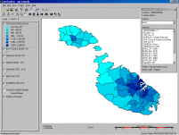
A specific walkthrough for the CensArc project has been created based on the Population Density dataset. Click on the image below to access the CensArc walkthrough or download the zipped Walkthrough (324K).
Home, MSc Project, Imagemapping Section, Census ArcExplorer Section, Population Pyramids, Links
Saviour Formosa Email: sformosa@europe.com