

![]()
The
study will take a look at a rapidly evolving technology that may serve
as a tool for improving accessibility and dissemination of data. The technology
of Web-mapping or Internet-mapping is investigated as per user-friendliness
and rapid access to data.
The relevance of the Internet to current
thinking is analysed, especially the prospect of reduced manual intervention
for map-generation and the elimination of ownership of dedicated map applications.
Further analysis would include a look into the upsurge of Web-mapping
initiatives with particular reference to the commercial-academic push-pull
factors. Different Web-mapping technologies, from low tech/low cost to
high tech/highly expensive systems, are looked into. The study will also
investigate data accessibility issues and will assess the socio and technological
barriers that hinder the same accessibility.
For the purpose of this study, a test
case, based on the Malta 1995 Census[1]
is planned, which study aims to investigate whether Web-mapping can serve
as a transporter for both tabular and mapped data. The case study attempts
to develop a working model of a Census Web-mapping service, through the
use of either GeoMedia Web Map[2]
as a high tech-system or an alternative dual system using low-tech image-maps
and interactive maps in conjunction with ArcExplorer[3].
Pre- and post-study questionnaires shall be carried out in order to assess
whether potential users see the necessity for further development of the
application.
![]()
Current GIS developments on the Internet
as a medium to convey data are based on the desire to access an international
network which users are familiar with, can be accessed from any location,
when required without the constraints of owning a proprietary software
for map-generation and data analysis. The web is relevant for GIS data
owners since data can be stored where users can find it, in a format that
they can read irrespective of platform or system they are using, as well
as using a common and inexpensive if not free browser.
Developments of applications for the
Web have been impressive. Software vendors have been quick to jump on
the bandwagon and initially provided applications based on existing GIS
with web code wrapped around them[i]
(Limp, 1999a). These first applications were very limited in scope and
allowed for only a small number of users. Later developments included
the ability to handle threading where many users can access the data since
each request is separated in packets and worked upon independently by
server software. The current applications make use of libraries of alternatives
that do the work of a full GIS package, based on Object-Oriented technology[ii]
(Hardy et al, accessed 1999).
The Internet emerged during the mid-1990s
as a dominant force especially with the launching of the World Wide Web,
even though its real origin can be traced to the 1960s[iii]
and was restricted to military and academic institutions (Kristula, 1997).
No study of phenomenology[iv]
(Natason et al, 1994) ever encountered such a rapidly evolving
occurrence, with some arguing over its own existence[v].
Society itself has yet to come to grips with the ramifications of the
web, how it will change the media, communications, research, study, warfare
and a multitude of other societal relationships. Sociology itself will
have to radically shake itself to face this new continuum. The Internet
has already become an integral part of society, and some returns decidedly
evident: on-the-second journalism, on-line bookstores and auctions, real-time
worldwide videoconferences, global research, remote consultancies during
medical intervention and home publishing
[vi]
(Plewe, 1997).
With the inception of the World Wide
Web (WWW), Internet use exploded and today it is quite unclear who is
pushing what. In turn this highlighted the push-pull debate on whether
academic institutions are pushing the development of Web-mapping or vendors
are pulling it along. White papers such as those produced by Intergraph[vii],[viii]
(developers of GeoMedia WebMap and GeoMedia Web Enterprise), have contributed
to this issue along with developments by organisations such as ESRI[ix]
(MapObjects, Arcview IMS), AutoDesk[x],[xi]
(Mac Gillavry, 1999), (MapGuide),
and MapInfo[xii]
(Mapxsite, Mapxtreme). Some kind of stabilization may be on the horizon
through initiatives such as the OpenGIS Web-mapping Testbed RFT[xiii],[xiv]
(Ferreira et al, 1998) and the TC/211 Geographic Information/Geomatics
Committee of the International Standards Organisation[xv],[xvi]
(Rowley, 1999 Levinsohn, 2000).
To date, some good on-line GIS applications
have been built, from the early stages of Internet development, examples
of which include the early XEROX PARC Map Viewer[xvii]
(launched June 1993) and the Virtual Tourist[xviii]
(launched January 1994). Since then, a multitude of map generating sites
has been created[4]. These include
some specialised sites where Web-mapping is highly advanced both in relation
to generic issues as well as in such specific areas as is Census Web-mapping.
An example of the former can be found at Delaware Data[xix],
which has a section comprising a transport interactive map linking the
user to live traffic cameras as well as having links to Census information.
Sites specific to the topic under study include that of the Detroit Empowerment
Zone Census Tracts Selection[xx]
with its highly interactive map by means of links to census tracts and
data.
Both
public and private organisations have seen the potential of Web-mapping
and are jumping to the challenge to produce better sites, however there
is Web-mapping and Web-mapping. Whilst it is desirable to have a fully-fledged
GIS on the web, some applications do not necessarily need the full-works;
some may need simple pre-formatted bit-maps, and others may need network
based collaborative GIS where remote users share data in real time.
A range of Web-mapping applications
is available for the developer with pre-drawn bitmaps at one end. Bitmaps
are very low-end solutions where little interaction can occur. At the
other end of the range is the sophisticated solution mainly used for Intranet
mapping but has the same potential for Internet mapping, where maps are
generated on a full GIS application that resides on the web-server. Such
a system is called Internet server-based GIS. Other Web-mapping solutions[xxi]
(Greenwood, 1999) exist such as:
o Image maps
- the most common Web-mapping sites in active service. Though pre-drawn,
they allow a certain level of interaction as users can jump to datasets,
other maps, html links, images, etc. through hot-links embedded in the
map itself.
o Map-generating
sites generally simple search engines that generate maps on the
fly. Road maps or location finders feature a lot in this area[xxii].
Users type in the name of a street and a map of the particular location
is provided.
o Third-party mapping
- a company creates the maps for a client and injects the same maps on
the clients web-page, but each map is linked to the companys site, where
the map actually resides. The user is not aware of the migration.
o Java applets
pre-written mini-applications that are becoming quite popular as a method
to display data and maps[xxiii],[xxiv].
Applets allow interactivity and work best on vector data where individual
features are made active.
o Mini GIS plugins
or Active X components - downloadable components that are installed
on the clients side and interact with the downloaded data from the web-server,
reducing data traffic and downloading.
o CGI Scripting
(Common Gateway Interface) - platform-independent protocols that interpret
user messages and translate them into instructions for server action returning
selective maps to the user.
But what do these applications imply
for such studies as the current one? The main preoccupation is that in
the process of developing the research study, the technology employed
would be obsolete, although the medium may be the same or upgraded, especially
with the much-flaunted Internet2[xxv]
development. This is where OpenGIS moves in. A GIS dataset with no allegiance
to any proprietary software or system will definitely be the one to survive
in such a rapidly evolving system. The user need not have a high-end software
at his/her end, the map/data generation tool resides in the servers end
and queries are resolved there. This implies that a user with a basic
browser can have access to data generating power from the comfort of ones
home or office..
In order to analyse whether Web-mapping does help to offset problems of accessibility and facilitates ease of use of data, a case-study shall be carried out on the Census 1995 of the Maltese Islands.
![]()
The Censuses[5]
in Malta were officially launched in 1842, following the introduction
of the Census in Great Britain in 1801 and covered the demographic as
well as the social and economic characteristics of the population. The
latest take in 1995 was authorised by Legal Notices[xxvi],[xxvii],[xxviii]
in terms of Section 3 of the Census Act of 1948[xxix]
and employed the De Jure enumeration method[xxx].
Most Census data in Malta is in analogue
(paper) format. Documents from the census takes of 1861[xxxi],
1871[xxxii],
1891[xxxiii],
1901[xxxiv],
1911[xxxv],
1921[xxxvi],
1931[xxxvii],
1948[xxxviii],
1957[xxxix],[xl],
and 1967[xli],[xlii],[xliii]
are in this format[6]. Though no
raw digital data exists for most of these Censuses, population data for
1957 and 1967 were inputted and presented in several formats, mainly as
tables and population pyramids[xliv].
The next Census was taken in 1985[xlv],[xlvi].
The Central Office of Statistics (COS)[xlvii]
and the University of Keele of the United Kingdom carried out the Census
take. Volumes I and III were produced covering the demographic aspects
and a demographic atlas respectively. Ironically, the Economic Activity
section, Volume II was never produced, presumably due to financial constraints.
Data in digital format exists for the
1985 Census, however it is stored in an archaic format and the gatekeepers
could only use specialised software (SPSS[7])
to access it. In addition to the limitations imposed by the software,
a greater barrier to accessibility is encountered: the human and policy
one. In order to access the data a complex system of requests to the gatekeepers
has to be made[xlviii].
The data requester has to ask for permission to access the data from the
COS who are the owners of the Census. Once approval is given, the researcher
has to approach another organisation (M.I.T.T.S. Ltd.[8])
for their approval to access the software. M.I.T.T.S. claim to be the
guardians of the data and as such no researchers other than themselves
can analyse the data for confidentiality reasons. Thus, access to the
data and outputs from the same data is severely restricted and can be
a daunting task.
The 1995 Census saw a changing aspect
to the dissemination of data to the public. Organisations such as the
PA that had collaborated with the COS and provided pre-Census services
(such as maps for enumeration areas, questions for the questionnaire[xlix],
etc) were requested to forward their requests for data from the Census
office. The data requested could only be given up to specific levels of
aggregation to safeguard the confidentiality clause of the Census Act.
Table 1 outlines the aggregation levels.
Table
1: Aggregation Levels for Census outputs,
1995
|
Aggregate |
Description |
|
National |
Total figures for all
island |
|
Islands |
Separate data for Malta
and Gozo |
|
Census Regions |
6 regions as outlined
by COS |
|
Localities |
67 localities also known
as Local Councils |
|
Enumeration Areas |
Aggregates of 150 households |
Prior to producing the digital data,
COS published a preliminary report for parliament in March 1996[l],
followed by population[li],
fertility[lii], nuptiality
and households[liii],
education and economic activity[liv],
migration[lv] and dwellings[lvi] publications.
All publications were in analogue format and information was at Locality
level and higher.
PA data was required in digital tabular
format[lvii] (Appendix
A), which requirement could not be accommodated, as this was not possible
at the time. Following continuous communications, data was presented
in *.lst files which is an SPSS output format. This entailed a process
of data conversion into database format by initially cleaning it from
artifacts and unwanted typos, then porting the text to a spreadsheet and
aligning all the datasets into one table. A list was prepared as per datasets
that have been converted and were used for the Web-mapping project (Appendix
B). This was accompanied by a time-consuming exercise entailing the documentation
of the steps taken through detailed lineages and error checking processes[lviii]
(Appendix C).
Had the data been provided in *.dbf
format all these problems should have been avoided. As such, even though
Census data is made available, the accessibility issue is still far from
solved. While the above indicates that data accessibility is to a certain
extent still very limited and restricted, once the PA has the converted
data the logical step would be to identify what steps the organisation
needs to take in order to disseminate its data as widely as possible and
in a user-friendly manner.
Diverse dissemination methods have
been used to date, ranging from presenting the data in PowerPoint[9]
presentation format (as in the case of the population pyramids), through
the use of a spreadsheet-based output using Excel[10],
to the preparation of a full-blown GIS based on MapInfo[11].
To add to the already complex situation, data presented to the PA also
needs to be analysed as against other data in diverse formats from other
organisations such as public domain information on income[lix]
and the Household Budgetary Survey[lx].
What most users really look out for
is a simple interface requiring as minimum intervention as possible. Few
users are prepared to go the way of a steep learning curve in addition
to acquiring expensive and high end software when they would rarely be
using it to its full potential.
Once the problem has been analysed
and the main options for dissemination covered, the next stage is to ascertain
whether Web-mapping is a reliable medium on which to develop the Census
service.
![]()
Census data is to a certain extent
an end in itself and cannot be updated until another Census is taken.
This situation brings up a query whether there is a need for a full service
based application.
On-line sites utilizing different web-mapping
technologies show that Census data can be mapped using the Internet as
the medium. These include: KINDS[12]
with their dataMapper and cdv[lxi];
SEDACs[13]
DDViewer and DDCarto[lxii];
SANDAGs[14] Interactive
Map[lxiii];
DemographicsNows[lxiv] Interactive
Demo Site; Caswebs[lxv]
Web-based Interface; DVRPC[lxvi]
Data Services[lxvii] Site;
Georgia Countys Census Data Map[lxviii];
and the United Nations Popmap[lxix]
project. These sites give evidence to the fact that Census-related databases
can be brought together with mapping technology on the Internet in order
to produce a live on-line analysis tool.
Whilst the availability of static image
maps is already satisfactory for most Census studies, users in the PA
identified further needs. A preliminary study in the organisation acknowledged
that users want data that they can manipulate and analyse. This is consonant
with what Charlton et al state is a prerequisite for sensible geographical
analysis, free from the tyranny of fixed arbitrary census geography[lxx]
(Charlton, 1995). One has to note that the 1985 Census maps[lxxi]
were presented for a limited and specific number of variables. Should
the 1995 data be made available on the web in the image map format each
image has to be linked to the particular data file, generating a nearly
unlimited number of outputs. This is especially more so since the data
can be presented at different aggregation levels. Presenting data at National
level is one thing, presenting it at Council (67 in number) and Enumeration
Areas (800+) is another. This apart from image maps for every age group,
job type, dwelling type, etc.
Therefore, a solution would be needed
where maps could be generated as per request either through a full server-based
GIS web-map solution or a dual system where the concept of image-mapping
is shown in conjunction with an application that would allow the user
to access the outputs across the web and generate maps at the users end
as developed by Tantalus Communications[lxxii]
through the use of free software as is ArcExplorer (Harder, 1998).
![]()
The study is based on the development
of a Census Web-mapping Service for the Maltese Islands. For this scope,
contact with diverse organisations has been established where hopefully
one high-tech solution would be made available for use for this research.
Two options are available for the research
strategy: either a full server-based GIS web-map solution (preferred strategy)
or a dual system integrating image-mapping together with a map-generating
and data querying application (alternative strategy). Figure 1 depicts
the two options.
Figure
1: Web-mapping Development Options
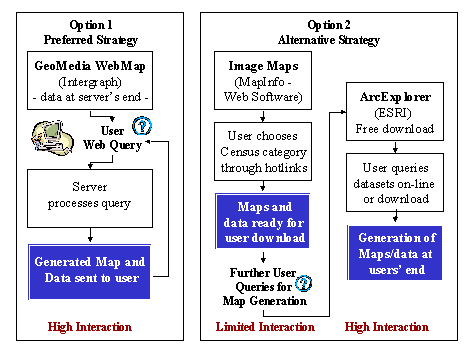
The first option involves GeoMedia
WebMap, which is a full server-based GIS web-map solution that would allow
users to access the Census data over Intranets and the Internet and generate
maps as well as tabular data. Since this development requires a steep
learning curve from the developer, and the development itself is still
a new concept, the aim of this section is to develop a working prototype
of the Census. However, should developments prove otherwise, a more extended
service would be attempted with more datasets put on-line. For this option,
programming support, mainly Java and VB scripting would have been made
available from PA colleagues from IT and Research Units.
One point to note at this stage concerns
the fact that at first the development will be presented on an Intranet
and following the post-development questionnaire feedback, decisions would
be taken on whether to develop the service further.
Should difficulties be encountered
in the first option, depending on software provision or development of
the service, an alternative option was prepared. This option involves
the setup of a hybrid system that brings together a low-tech image-map
system with a web-map application (ArcExplorer), which would be installed
at the users end and accesses data and maps over the Internet. This dual
system would allow the user to view examples of the maps that can be generated
by Census category (ex. Gender and age, dwelling stock). Should they need
further information, ArcExplorer would facilitate access to data in order
to generate maps or data queries as they deem fit from the large number
of combinations available. ArcExplorer would also allow the user to export
data and maps for external use.
Each of these options is a viable investigative
tool to deduce whether Web-mapping would facilitate data accessibility.
Though it would be desirable to develop a full-server based application,
the dual system would still prove a challenge.
![]()
The study shall endeavor to explore
how Web-mapping caters for the needs of users and analyses whether it
is the best solution to present Census data on the web for dissemination.
The main aim of this research is to make the data available using the
most appropriate solution, through an easily accessible medium. The research
will aim to produce a working Census Web-mapping prototype that the users
will then analyse and from their feedback decisions can be taken whether
the technology can be further developed as per other datasets within the
Planning Authority.
In conclusion, the study shall endeavor
to investigate whether Web-mapping is a viable solution to all the accessibility
issues that Census researchers encounter to date in Malta.
![]()
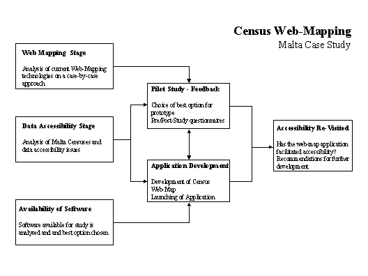
The Thesis is structured as follows,
whereas Figure 2 gives a graphic description of the perceived stages:
Figure
2: Research Development Stages
Chapter 1 Introduction: unlocking
data inaccessibility through Web-mapping
·
The
Extended Outline forms the basis of the first Chapter, mainly the issue
of data accessibility and the integration of Census and Web-mapping.
Chapter 2 Web-mapping and accessibility
how are Web-mapping technologies being utilised?
·
are
the main current uses the only technology for the future? An analysis
of the past, present and future: a case-by-case approach. What are the
problems of accessibility vis-à-vis data.
·
What
Web-mapping technologies exist: full-blown software, imagemaps, cgi, hotlinks,
database availability, live data, etc. How do they facilitate access to
date?
·
Census
can be produced as an ongoing process for a place as small as Malta through
the integration of data on-line from different.
·
What
other options are there as against Web-mapping?
·
What
does the study involve?
·
How
was the data made available, how was it converted, what was the process
to produce the current state of data?
·
What
software was used and why was that option taken?
·
Is
it worth the effort and will users benefit from the data made available:
are requests continuous in the organisation under study.
·
Describe
how the data works (as a manual and also compare costs of setting up as
against use).
·
Make
data available for use by the University and other researchers.
·
Create
Help file for users either as a separate document or as an HTML file.
·
Does
the product relate to the general ideas set out above?
·
Critique
of method and how the results can be improved.
·
Who
are the test recipients?
·
Pre-development
questionnaire. Who was consulted prior to initiating the study? What were
their initial requests for data availability? Why do they need the data?
What are their options for accessibility as regards the current data?
What was their initial feedback?
·
Post-development
questionnaire. What do they think of the service? Do they approve of it?
Does it facilitate their access to data?
·
What
are their comments on future accessibility and whether they would go for
a more complete web-service with on-line data and real-time querying capabilities.
Considering the fact that the Census is a static dataset what can be added
to it in order to provide extensions to the product for updated use?
·
Weighting
the outcome: Pros and cons resulting from their comments, which comments
should be retained for further development or discarded and why?
·
What
are the pros and cons of such an exercise?
·
What
are the points that result in improvement of the service? Has the exercise
in Web-mapping proved its worth? Is data really accessible to all? Is
software too expensive? Is the technology developing too fast to make
sense for the web-map developer? How does the user fit in all this?
·
Does
Census availability as a web-map alleviate problems of access to data?
Has accessibility been vindicated?
·
Would
going for a more extensive service be ideal, especially as regards to
doing away with multiple-licenses and user-registrations from proprietary
software.
·
Recommendations
·
Recommendations
resulting from the study
·
Recommendations
for further study/research
![]()
[1] Test case will be based on Census data presented to the Malta Planning Authority (PA) by the Central Office of Statistics (COS)
[2] Developed by Intergraph Corporation
[3] ESRI ArcExplorer v1.1, Environmental Systems Research Institute Inc.
[4] The Bibliography accompanying this document lists over 400 sites that are being assessed and segmented into sections, mainly: interactive web map sites, map generating sites, web mapping documents and link pages, related web publishing sites, JavaScript and applets, census interactive web sites, and census web sites.
[5] The Census is a process of collecting, compiling and publishing demographic, economic and social data relating to the whole population at a given time.
[6] Copies of the 1842, 1851, 1881 documents have yet to be traced at the National Library.
[7] Statistical Package for the Social Sciences, SPSS Inc.
[8] Management Information Technology Training Services Ltd., Malta.
[9] Microsoft PowerPoint 2000 presentation format, Microsoft Corporation
[10] Microsoft Excel 2000 spreadsheet format, Microsoft Corporation
[11] MapInfo Professional v5, MapInfo Corporation.
[12] Knowledge Based Interfaces to National Data Sets
[13] Socioeconomic Data and Applications Center
[14] San Diego Association of Governments
![]()
[i] Limp F., (1999a), Mapping Hits Warp Speed on the World Wide Web!, GeoWorld - Sept 99 http://www.geoplace.com/gw/current/999TEC.ASP
[ii] Hardy P.G. & Woodsford P.A., (Date accessed 1999, (no date given for presentation of document - web indicates previous papers dated as 1998), Mapping with live features: Object-Oriented representation, Laser-Scan Ltd, UK, http://www.lsl.co.uk/papers/12livefeat.htm
[iii] Kristula D., (March 1997), The History of the Internet,
[iv] Natason M.A., Edie J.M., and Wild J. (eds), (1994), Phenomenology and the Social Sciences, Vol. 1, Northwestern University Press, ISBN: 0810106167
[vi] Plewe Brandon, (1997), GIS Online: Information Retrieval, Mapping and the Internet, OnWord Press, ISBN: 1566901375
[vii] Internet/Intranet Online Publishing, (1999), Intergraph
- GeoMedia Web Map - Knowledge Center - White Paper,
http://www.intergraph.com/software/gwmregister/white_paper.asp
[viii] GeoMedia Web Applications - GIS for the Web, (July
1999), Intergraph - GeoMedia Web Applications - White Paper,
http://www.intergraph.com/software/geoengineering/press/gwe_white.asp
[ix] ESRI, (April 1999), ESRI Announces New Web Mapping
Technology,
[x] Autodesk http://www.autodesk.com/mapguide
[xi] Mac Gillavry E., (September 1999), Autodesk MapGuide 4.0 (Review), - GEOEurope Vol 8, Issue 9 September 1999, GeoTec Media, Huntingdon, UK, Advertorial - Web Special, http://www.ge.geoplace.com
[xii] MapInfo, http://www.mapinfo.com
[xiii] OpenGIS Consortium Inc., http://www.opengis.org
[xiv] Ferreira J. Jr. & Evans J.D., (December 1998), A Web-based server for digital orthophoto libraries, - Response to OpenGIS Web Mapping Testbed RFT, Massachusetts Institute of Technology, http://tull.mit.edu/MIT-RFT-response.html
[xv] Rowley J., (November 1999), Raising the Standards for Web Mapping, GEOEurope Vol 8, Issue 11 November 1999, GeoTec Media, Huntingdon, UK, http://www.geoplace.com
[xvi] Levinsohn A.G., (April 2000), Stirring the Spatial Soup, GEOEurope, GeoTec Media, http://www.geoplace.com
[xvii] Xerox PARC Map Viewer (1.0X), http://mapweb.parc.xerox.com/map
[xviii] Virtual Tourist, http://www.vtourist.com/webmap/
[xix] Delaware Data (RDMS/UD), (has an interesting section comprising a transport interactive map linking user to live traffic cameras at http://www.state.de.us/deldot/cam/index.html and links to Census information, http://www.rdms.udel.edu/rdms/main/deldata.html
[xx] Detroit Empowerment Zone Census Tracts Selection http://www.cus.wayne.edu/Mimic/dezone_tracts.htm
[xxi] Greenwood C., (August 1999), Internet mapping made simple, Mapping Awareness August 1999, Vol 12 No 7, GeoTec Media, Huntingdon, UK, Pg 31-32, http://www.geoplace.com
[xxii] MapQuest, http://www.mapquest.com/
[xxiii] An Interactive Map of The University of British Columbia, http://sunsite.ubc.ca/UBCMap
[xxv] Internet2 http://www.internet2.edu/
[xxvi] Legal Notice Number 134 of 1995, (1995), Government Gazette, Department of Information, Malta
[xxvii] Legal Notice Number 660 (19th October 1995), Government Gazette, Department of Information, Malta
[xxviii] Legal Notice Number 166 of 1995, (1995), Government Gazette, Department of Information, Malta
[xxix] Act Number II of 1948, Laws of Malta, Government of Malta, Valletta, Malta
[xxx] Census 85, (1986), Vol. I A Demographic Profile of Malta and Gozo, Central Office of Statistics, Government Press, Malta
[xxxi] Giglio A., (1863), Census of the Islands of Malta, Gozo and Comino 1861, Taken on 31st October 1861, Malta Government Printing Press, Malta
[xxxii] Barbar E. and Chapelle L., (1872), Census of the Malta, Gozo and Comino 1871, (1872), Taken on 3rd May 1871, Malta Government Printing Press, Malta
[xxxiii] Census of the Maltese Islands 1891, (1892), Taken on Sunday 5th April 1891 under Ordinances II and III of 1891, Malta Government Printing Office, Malta
[xxxiv] Census of the Maltese Islands 1901, (1903), Taken on Sunday 31st March 1901 under Ordinances X of 1900 and III of 1901, Malta Government Printing Office, Malta
[xxxv] Census of the Maltese Islands 1911, (1912), Taken on Sunday 2nd April 1911 under Ordinance VII of 1910, Malta Government Printing Office, Malta
[xxxvi] Census of the Maltese Islands 1921, (1922), Taken on Sunday 24th April 1921 under Ordinance X of 1920, Malta Government Printing Office, Malta
[xxxvii] Census of the Maltese Islands 1931, (1932), Taken on Sunday 26th April 1931 under Ordinance XI of 1930, Malta Government Printing Office, Malta
[xxxviii] Eleventh Census of the Maltese Islands 1948, (1948), Taken on 14th June 1948 under the Authority of ACT II of 1948, Government Printing Office, Progress Press, Co. Ltd., Valletta, Malta
[xxxix] Malta Census 1957: The Maltese Islands, (1959), Report on Population and Housing, Central Office of Statistics, Department of Information, Malta
[xl] Malta Census 1957: The Maltese Islands, (1959), Report on Economic Activities, Central Office of Statistics, Department of Information, Malta
[xli] Malta Census 1967, (1967), Report on Population Characteristics, Census Office, Central Office of Statistics, Department of Information, Valletta, Malta
[xlii] Malta Census 1967, (1967), Report on Economic Activities, Volume I, Census Office, Central Office of Statistics, Department of Information, Valletta, Malta
[xliii] Malta Census 1967, (1967), Report on Economic Activities, Volume II, Census Office, Central Office of Statistics, Department of Information, Valletta, Malta
[xliv] Strategic Planning Unit, (1997), Population Pyramids: A Local Perspective, Strategic Planning Unit, Malta Planning Authority
[xlv] Census 85, (1986), Vol. I, op. cit.
[xlvi] Census 85, (1987), Vol. III A Computer-Drawn Demographic Atlas of Malta and Gozo, Department of Geography, University of Keele, England in collaboration with the Central Office of Statistics, Government Press, Malta
[xlvii] Central Office of Statistics, Malta http://www.magnet.mt/home/cos/
[xlviii] 1985 Census File RI/01, (1995), Strategic Planning Unit, Malta Planning Authority
[xlix] Census 1995 Questionnaire, (1995), Censiment tal-Popolazzjoni u tad-Djar 1995 Kwestjonarju, Central Office of Statistics, Malta
[l] Census of Population and Housing 1995, (March 1996), Preliminary Report, Central Office of Statistics, Valletta, Malta
[li] Census of Population and Housing 1995, Volume 1 - Population, Age, Gender and Citizenship - Final Report, (1997), Central Office of Statistics, Department of Information, Valletta, Malta, ISBN: 99909-81-16-7
[lii] Census of Population and Housing 1995, Volume 2 - Fertility - Final Report, (1997), Central Office of Statistics, Department of Information, Valletta, Malta, ISBN: 99909-81-17-5
[liii] Census of Population and Housing 1995, Volume 3 - Nuptiality and Households - Final Report, (1998), Central Office of Statistics, Department of Information, Valletta, Malta, ISBN: 99909-81-25-6
[liv] Census of Population and Housing 1995, Volume 4 - Education and Economic Activity - Final Report, (1998), Central Office of Statistics, Department of Information, Valletta, Malta, ISBN: 99909-81-28-0
[lv] Census of Population and Housing 1995, Volume 5 - Migration, Returned Emigrants and Miscellaneous - Final Report, (1998), Central Office of Statistics, Department of Information, Valletta, Malta, ISBN: 99909-81-32-9
[lvi] Census of Population and Housing 1995, Volume 6 - Dwellings - Final Report, (1998), Central Office of Statistics, Department of Information, Valletta, Malta, ISBN: 99909-81-39-6
[lvii] Census 95, (1995), A Strategic Planning Unit Exercise aimed at collecting population and housing data for planning purposes, Strategic Planning Unit, Malta Planning Authority - (Censufin.doc)
[lviii] Census 1995: Data Integration File, File RI/03c, (1998), Strategic Planning Unit, Malta Planning Authority
[lix] National Accounts, (1994), Central Office of Statistics, Malta
[lx] Household Budgetary Survey 1994, (1997), Central Office of Statistics, Department of Information, Valletta, Malta, ISBN: 99909-971-2-8
[lxi] KINDS - Knowledge Based Interfaces to National Data Sets http://lenny.mcc.ac.uk/kindsdb6/
[lxii] Socioeconomic Data and Applications Center - Interactive Applications (original site for DDViewer but includes other services) http://sedac.ciesin.org/#intapp
[lxiii] Census (has interactive mapping section with clear output) http://www.sandag.cog.ca.us/ftp/html/projects/ris/census/census.html
[lxiv] DemographicsNow.com (commercial site advertising interactive mapping in a variety of formats - presents sample examples of interactive maps - even provides the possibility of accessing free Wyoming data upon registering) http://www.demographicsnow.com/
[lxv] Casweb Census Interactive tool (java based - need to apply for a login name and password) http://census.ac.uk/casweb/
[lxvi] Delaware Valley Regional Planning Commission
[lxvii] DVRPC/ Data Services http://www.dvrpc.org/data/rin.htm
[lxviii] Interactive Georgia County Census Data Map (interactive map - gives data on right frame when mouse passes over map link) http://www.cc.emory.edu/CRL/abb/mapping/pick_county.html
[lxix] Health Atlases On the Internet http://www.un.org/Depts/unsd/softproj/pmappl/overview/sld171.htm
[lxx] Charlton M., Rao L. and Carver S., (1995), GIS and the Census, IN Openshaw Stan (ed), (1995), Census Users Handbook, GeoInformation International, John Wiley and Sons, Incorporated, ISBN: 1-899761-06-3
[lxxi] Census 85, (1987), Vol. III, ibid
[lxxii] Harder Christian, (1998), Serving Maps on the Internet: Geographic Information on the World Wide Web, Environmental Systems Research Institute (ESRI), ISBN: 1879102528, Pg 36-38
![]()
Home, MSc Project, Imagemapping Section, Census ArcExplorer Section, Population Pyramids, Links
Saviour Formosa Email: sformosa@europe.com